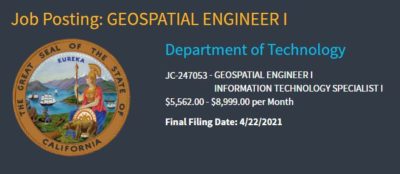
3/11/2021 Meeting Notes Posted
The Notes from the March 11, 2021 GIS Council Meeting have been posted for your information and reading pleasure at this link.
Enabling the California geospatial community
The Notes from the March 11, 2021 GIS Council Meeting have been posted for your information and reading pleasure at this link.
TO: Users of the National Hydrography Dataset (NHD) in California USGS has informed us that they are experiencing some technical problems with their staged NHD products that are available for public download from their website: https://www.usgs.gov/core-science-systems/ngp/national-hydrography/access-national-hydrography-products – scroll down the…
Read more
Some notes and links have been added to the posted agenda.
NMCorps Mapping Challenges continue on the Pacific coast with a new challenge for schools in California and Nevada! This is an excellent challenge for Peer Reviewers and Advanced Editors since all the existing points have already been edited, but there are many points needing to be reviewed. Don’t forget to look…
Read more
The Department of Toxic Substances Control (DTSC) is tasked with tracking and permitting the transportation of hazardous waste throughout the state of California but has historically struggled with a more real-time view into that data. Roger Cleaves, IT Specialist, will…
Read more
All in the California GIS community are welcome to attend the March 11, 2021, 10:00 a.m. to 12 noon quarterly meeting of the GIS Council. The agenda is available at this link . This web meeting will be held via…
Read more
The National Map – Applications The National Map’s applications are now hosted at apps.nationalmap.gov. To help facilitate this transition, traffic to viewer.nationalmap.gov is automatically redirecting to the new application URLs. We encourage you to update any bookmarks you have for…
Read more
Please register to attend the next quarterly meeting of the California GIS Council by filling out the form at this link. After you submit the form, the confirmation message will provide the Teams meeting connection information. Copy and paste that…
Read more
Dear colleagues, The USGS National Geospatial Program is again updating the US Interagency Elevation Inventory. We invite you to provide us information so that your data is discoverable by others. Your data need not be in the public domain, and the…
Read more
TNMCorps Mapping Challenges continue along the Pacific Coast with a challenge for fire stations in California, Nevada, and Arizona! We speculate many are still missing and the green dots show data points that need validation. Please note there are numerous…
Read more