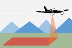
The CGIA Community Forum (formerly known as the California GIS Council) is pleased to invite all in the California GIS Community of Practice to attend the LiDAR for California Forum on Thursday, December 5, 2024, at 12 noon to 1:30 pm. Join us on Zoom as we mark a significant milestone: LiDAR data covering the entire state has been acquired through the USGS 3D Elevation Program! Join Nathaniel Roth, Chief Science and Data Advisor for the Department of Conservation, and Drew Decker, the USGS National Map Liaison for California, and a panel of subject matter experts* for a lively discussion on the many uses of LiDAR data and derivative products. The first hour of presentations will be recorded and shared on the CGIA website afterwards. The last half hour will be open for audience questions.
To register for this event, please fill out the form at this link, and then watch your email for confirmation and the link to join the Zoom session. Please don’t forget to add the item to your calendar.
*Panelists will join us from California Department of Conservation, Calfire, California Department of Water Resources, County of Los Angeles, California Land Surveyors Association, CSU Chico, and CSU Northridge.
Questions about this event may be directed to Jane Schafer-Kramer at jane.schafer-kramer@water.ca.gov This event is a presentation of the California Geographic Information Association. https://cgia.org.
Agenda: https://cgia.org/cagiscouncil/wp-content/uploads/2024/12/December-2024-Agenda-LiDAR-for-CA-Forum.pdf