
Congratulations to this year's winners!
Student Award | Associate Degree/Certificate
1st Place - Naomi Yates, Shasta College
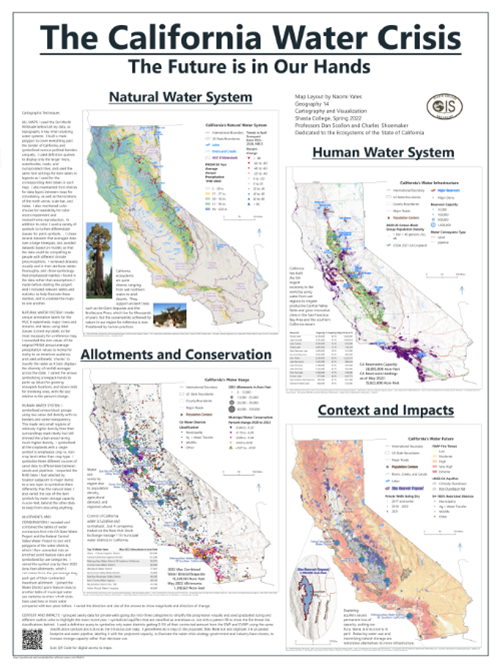
Naomi won the award with an outstanding 4-panel map of California. It is rich with content and utilizes a range of GIS and cartographic skills focusing on the California water crisis. The map panels include:
1) Natural water systems, such as rivers and watersheds.
2) Human water systems, including dams and reservoirs.
3) Allotments and conservation, focusing on municipal water conservation.
4) Context and impacts, highlighting fire risk and well and aquifer depletion.
For each of the component maps, attention to detail is outstanding.
Student Award | 4-year college/university
1st Place - Amanda Portier, University of California Davis
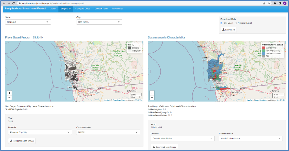 The winning project examines whether federal programs are channeling investment dollars into gentrifying neighborhoods in the United States. In her role as a research assistant, Amanda conducted a literature review of the various approaches to quantifying gentrification. She collected and cleaned large amounts of data, produced descriptive statistics and maps, performed sophisticated statistical techniques (such as spatial multivariate regression modelling), wrote summaries of her findings, and presented her results at the UC Davis Undergraduate Research conference. A web mapping application was created to display the data to the public. The purpose of the app is to share data with the policy and scholarly community so that they can conduct their own analyses and draw further insights. Amanda created the app from the ground up and has received positive reviews from policymakers and practitioners in the field.
https://neighinvestproject.shinyapps.io/neighborhoodinvestmentproject/
Student Award | Graduate
1st Place - Andrew Pineda, California State University Long Beach
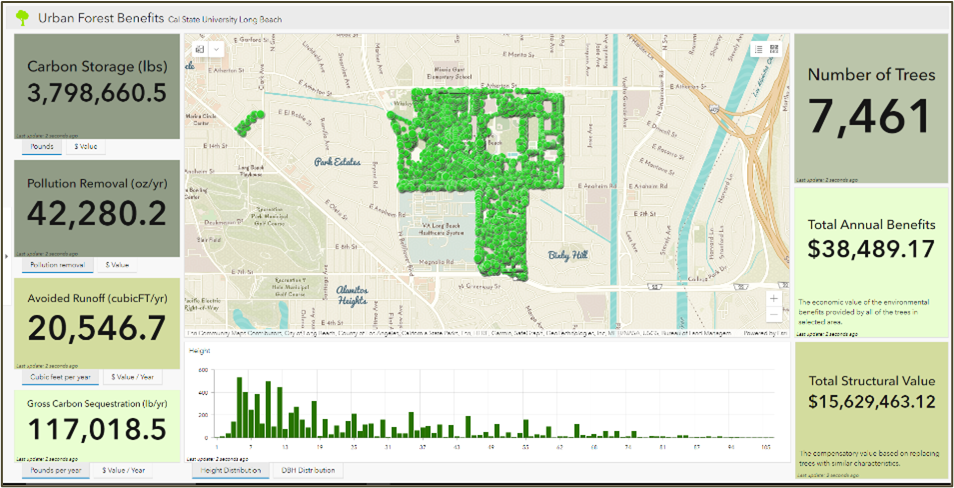 Andrew Pineda is awarded 1st place for his project quantifying the benefits of trees using i-Tree Eco. Now more than ever it is important to realize that trees are an asset and need to be advocated for by conveying the benefits of trees to all stakeholders. This project makes use of mapping techniques including web mapping, html web development, 3D mapping, deep learning, and Arcade-scripted pop-ups to convey and quantify the ecosystem services of trees.
https://benefits-of-trees-csu-long-beach-csulb.hub.arcgis.com/
2nd Place - Philip Thomas Hess, USC Spatial Sciences Institute
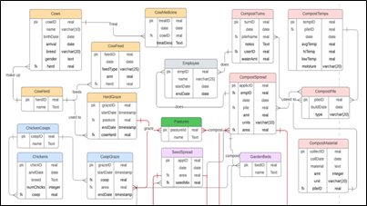 Despite regenerative agriculture's complex record-keeping requirements, it is not well supported by current farm management software, which usually developed for industrial (monoculture) agriculture. These farm records rely heavily on farmer’s memory, paper notes, and computer spreadsheets. Most of the time, dynamic spatial relationships between animal movement and plant operations on the ground are not considered. The animals and crops all have significant temporal, spatial, and attribute data associated with them and would be best organized in a spatial database. Mr. Hess worked with regenerative farm practitioners to create a functional spatial database for individual farm management. He tested its utility with data from a regenerative farm in Ventura County, CA. The database represents dozens of relevant agricultural features (e.g., animal herds, orchard trees, annual crops, compost, irrigation lines), their attributes (including spatial and temporal data), and their relationships (such as when the pasture was last seeded, or which beehives are close to native plants). Mr. Hess’ spatial database demonstrates that spatial and temporal regenerative farm data can be stored, updated, and queried efficiently to support farm business operations moving toward a sustainable future. His accompanying thesis considers the flexibility of database adaption to individual farms. In includes simple and complex spatial-temporal queries to encourage GIS technology use in today’s farm record-keeping and management.
Exemplary Use of GIS
1st Place - Devon Hedemark, City of Shasta Lake
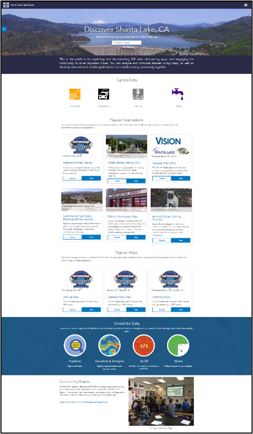
Devon Hedemark has been an active member of the Redding-area GIS community for over a decade. In his current capacity as GIS Coordinator for the City of Shasta Lake, Devon has done a remarkable job. Among his accomplishments is implementing a public-facing open data and interactive maps site where support staff and citizens can access general purpose layers, along with traffic counts and road construction information. Furthermore, as an active member of the North State GIS community, Devon acts to promote GIS and outreach to the community. In this capacity he has been chair of both the Far North Regional GIS Council and the Redding Area GIS User group and is a steering committee member for the NorthStateGIS.org web platform.
https://cityofshastalake.org/1153/GISMaps
Outstanding Geospatial Web Application
1st Place - Shannon Julius and Robert Graham, Los Angeles County
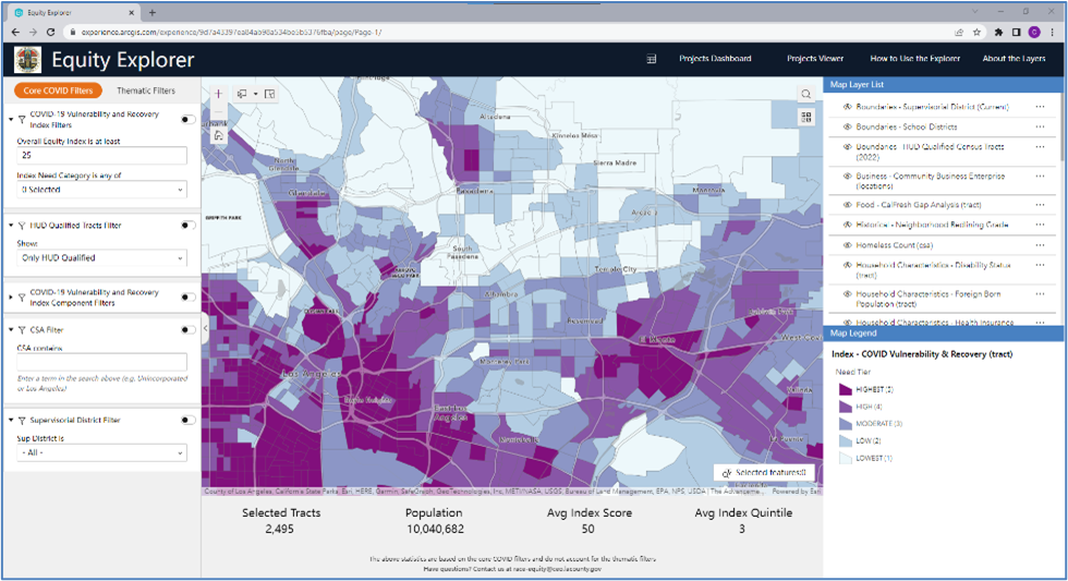
With the allocation of Federal funding for COVID recovery, the Board of Supervisors sought to develop a more equitable means of allocating funds using data-driven approaches. The goal was to ensure that the communities most in need would receive the largest allocations. The Enterprise GIS (eGIS) Section was approached to help tackle this goal by drawing together a wide array of geospatial data to develop equity indices based on a range of socioeconomic and other factors at the census tract level. The Equity Explorer, developed primarily by Shannon Julius and Robert Graham, assists county Departments to plan and implement programs to serve their intended target populations more effectively. The County office of Anti-Racism, Diversity, and Inclusion (ARDI) reviews all proposed projects using the Equity Explorer, a web mapping application which allows both internal users and the public to better explore, understand and review a plethora of relevant data.
The tool allows users to explore census tracts to identify areas of highest need, based on populations disproportionately affected by COVID-19. Communities are stratified into five Need Tiers based on COVID-19-related risk, severity, and recovery indicators. Filters allow users to access summary statistics for geographies down to the census tract level. The successful use of geospatial data and indices has already led to positive outcomes and while COVID recovery funding continues, the Equity Explorer is already being leveraged by County departments and executives as a basis for review of other county projects and funding allocations.
https://experience.arcgis.com/experience/9d7a43397ea84ab98a534be5b5376fba/page/Page-1/
Chair Award
An-Min Wu, USC Spatial Sciences Institute
 In addition to being an active member of the CGIA board and previous chair, An-Min Wu, Ph.D., is an Assistant Professor in the Spatial Sciences Institute at the University of Southern California Dornsife College of Letters, Arts and Sciences.
An-Min teaches spatial databases, spatial data acquisition, spatial analysis, and geospatial technology project management in the online Geographic Information Science and Technology (GIST) Graduate programs and principles of spatial data analysis in the interdisciplinary doctoral program in population, health, and place. She also serves as thesis advisor to M.S. students in GIST.
gis.usc.edu/faculty/an-min-wu/